
Despite Tropical Storm Beryl making landfall on the morning of Monday, July 8, relatively sunny conditions returned as the remnants of the system moved north-eastward, according to analysis using the Solcast API. Although southeast Texas was most affected by damaging winds and flooding, the cloud cover from the inclement weather system did see a large but temporary dip in solar generation potential across the state.
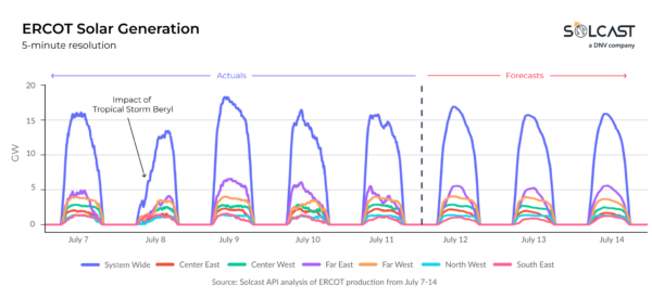
Solcast’s analysis of potential utility-scale solar generation in the ERCOT electricity grid region indicates that the cloud cover associated with Beryl significantly dampened solar generation on the morning of Monday the 8th. Cross-referencing with grid operator reports reveals that very little production went offline due to the storm, showing the resilience of Texas’ solar infrastructure.
By Tuesday, skies over Texas were relatively clear, with only isolated convective storms as Beryl moved northeast. Forecast thunderstorms for the coming weekend are likely to only put a mild dampener on solar generation in the ERCOT electricity region, with the southeast the most impacted, according to forecasts from the Solcast API.

When comparing the second week of July to previous years, overall ERCOT production this week is expected to be only 3% below typical generation levels. However, the southeast and Far East sub-regions of ERCOT were more significantly impacted by the cloud cover from Beryl, with generation more than 15% below average for the week, showing the localized nature of the storm’s impact on solar generation.
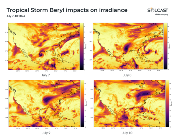
Tracking Beryl’s impact on daily irradiance shows a relatively small, well-structured storm on Sunday the 7th, just before landfall. As the storm moved northeast and rapidly weakened, the peak severe weather near its core diminished, but the spatial impact on irradiance increased as the system lost structure and spread out. This pattern shows how the storm’s dissipation affected solar generation potential across a broader area.
Solcast produces these figures by tracking clouds and aerosols at 1-2km resolution globally, using satellite data and proprietary AI/ML algorithms. This data is used to drive irradiance models, enabling Solcast to calculate irradiance at high resolution, with typical bias of less than 2%, and also cloud-tracking forecasts. This data is used by more than 300 companies managing over 150GW of solar assets globally.
The views and opinions expressed in this article are the author’s own, and do not necessarily reflect those held by pv magazine.
This content is protected by copyright and may not be reused. If you want to cooperate with us and would like to reuse some of our content, please contact: editors@pv-magazine.com.


By submitting this form you agree to pv magazine using your data for the purposes of publishing your comment.
Your personal data will only be disclosed or otherwise transmitted to third parties for the purposes of spam filtering or if this is necessary for technical maintenance of the website. Any other transfer to third parties will not take place unless this is justified on the basis of applicable data protection regulations or if pv magazine is legally obliged to do so.
You may revoke this consent at any time with effect for the future, in which case your personal data will be deleted immediately. Otherwise, your data will be deleted if pv magazine has processed your request or the purpose of data storage is fulfilled.
Further information on data privacy can be found in our Data Protection Policy.